Winnipeg Route 95
| Roblin Boulevard Corydon Avenue | ||||
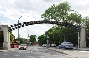
 Corydon Avenue arch | ||||
| Route information | ||||
| Maintained by City of Winnipeg | ||||
| Length | 10.8 km[1] (6.7 mi) | |||
| Existed | 1966–present | |||
| Known for | Confusion Corner, Little Italy | |||
| Major junctions | ||||
| West end | Route 105 (Grant Ave) | |||
| East end | Route 42 / Route 62 | |||
| Location | ||||
| Country | Canada | |||
| Province | Manitoba | |||
| Highway system | ||||
| ||||
Route 95 is a city route located in Winnipeg, Manitoba. It runs in the southwest part of the city from Route 105 east to Route 42, near the Confusion Corner intersection. It is named Roblin Boulevard west of Assiniboine Park, where it then becomes Corydon Avenue for the remainder of its route.[2]
Corydon and Roblin
The Corydon Avenue segment of the route is home to Winnipeg's Little Italy District, and is currently served by the 18 North Main-Corydon Winnipeg Transit bus route. The avenue was named after Corydon Partlow Brown, a member of the Legislative Assembly of Manitoba from 1878 to 1888.[3]
The more westerly Roblin Boulevard segment serves as the main street for the area of Charleswood. It was named for former Manitoba premier Rodmond Roblin, grandfather of Duff Roblin.[3]
Major intersections
From west to east, all intersections are at-grade unless otherwise indicated:[2]
| Street Name | Location | km[1] | mi | Destinations | Notes |
|---|---|---|---|---|---|
| Roblin Boulevard | Charleswood | 0.00 | 0.00 | Route 95 western terminus | |
| 1.55 | 0.96 | ||||
| 1.79 | 1.11 | Alcrest Drive | |||
| Tuxedo | 4.15 | 2.58 | Conservatory Drive / Shaftesbury Boulevard | Access to Assiniboine Park | |
| Corydon Avenue | Roblin Boulevard east end • Corydon Avenue west end | ||||
| 5.15 | 3.20 | Tuxedo Avenue | |||
| 5.94 | 3.69 | ||||
| River Heights | 6.22 | 3.86 | CN Oak Point Subdivision | Abandoned as of November 2000[4] | |
| 6.69 | 4.16 | CP La Riviere Subdivision | Level crossing | ||
| 6.71 | 4.17 | BNSF Manitoba Yards | Level crossing | ||
| 7.96 | 4.95 | Waverley Street | One-way southbound | ||
| 8.17 | 5.08 | Cambridge Street | |||
| Rockwood | 8.19 | 5.09 | East end of divided section | ||
| 8.79 | 5.46 | Wilton Street | |||
| 9.13 | 5.67 | Harrow Street | |||
| 9.30 | 5.78 | ||||
| Little Italy | 9.65 | 6.00 | Lilac Street | ||
| 10.34 | 6.42 | Daly Street | |||
| Confusion Corner | 10.79 | 6.70 | Route 95 eastern terminus | ||
| 10.87 | 6.75 | ||||
| 11.00 | 6.84 | Donald Street | Corydon Avenue eastern terminus | ||
1.000 mi = 1.609 km; 1.000 km = 0.621 mi
| |||||
References
- ^ a b Google (November 22, 2021). "Route 95 in Winnipeg, Manitoba" (Map). Google Maps. Google. Retrieved November 22, 2021.
- ^ a b Sherlock Publishing (2016). Sherlock's Map of Winnipeg (Map) (20th ed.). Winnipeg: Sherlock Publishing. pp. 17, 22–24. ISBN 1-895229-84-7.
- ^ a b "Charleswood Historical Society" (PDF).
- ^ "Manitoba Business: Canadian Northern Railway / Canadian National Railway". Retrieved November 22, 2021.