R767 (Republic of Ireland)
Jump to navigation
Jump to search
| Bóthar R767 (Irish) | |
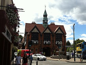
 Bray Town Hall at junction of R767 and R761 | |
| Route information | |
| Length | 3 km (1.9 mi) |
| Location | |
| Country | Republic of Ireland |
| Primary destinations |
|
| Highway system | |
The R767 is a regional road in Ireland which connects J7 (Bray South) of the N11 to Bray Town Hall on Bray Main Street. The majority of the road is known as the Killarney Road.
Route
The route begins at the Kilcroney Interchange (J7 Bray South/Greystones North), which is one of the busiest junctions in the country. The route crosses the N11 and meets the Ram Roundabout. The road then travels northwest towards Bray. The R767 passes through many of Bray's southwestern suburbs, such as Ballywaltrim, Oldcourt, Killarney and King Edward Road. The route terminates at its junction with the R761 at Bray Town Hall.