R699 (Republic of Ireland)
Jump to navigation
Jump to search
| Bóthar R699 (Irish) | ||||
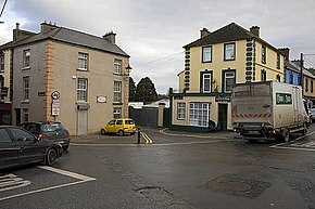
 Mill Street, Callan, on the R699 | ||||
| Route information | ||||
| Length | 18.1 km[1][2] (11.2 mi) | |||
| Major junctions | ||||
| From | ||||
| ||||
| To | ||||
| Location | ||||
| Country | Republic of Ireland | |||
| Highway system | ||||
| ||||
The R699 is a regional road in County Kilkenny, Ireland. It connects the N76 with the R448, via the M9. The road travels through the town of Callan and the villages of Dunnamaggin and Knocktopher.[2] The road is 18.1 kilometers (11.2 mi) long.[1][2]
References
- ^ a b Google (28 October 2020). "N76 to R448" (Map). Google Maps. Google. Retrieved 28 October 2020.
- ^ a b c "S.I. No. 54/2012 – Roads Act 1993 (Classification of Regional Roads) Order 2012". Government of Ireland. 28 February 2012. Retrieved 28 October 2020.