R466 (Republic of Ireland)
Jump to navigation
Jump to search
| Bóthar R466 (Irish) | |
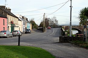
 R466 in O'Briensbridge | |
| Route information | |
| Length | 32 km (20 mi) |
| Location | |
| Country | Republic of Ireland |
| Primary destinations |
|
| Highway system | |
The R466 is a regional road in Ireland which runs southeast-northwest from the R445 at Birdhill, County Tipperary to the R352 in East Clare.
After leaving the R445 at Birdhill it passes through Montpelier before crossing the River Shannon at O'Briensbridge in County Clare via a narrow 14-arch bridge. It veers northwest for the rest of the route, passing through Broadford and O'Callaghans mills before terminating at a junction with the R352.
The route is 32 km (20 mi) long.