R458 (Republic of Ireland)

From the AARoads Wiki: Read about the road before you go
Jump to navigation Jump to search

R 458

Bóthar R458 (Irish)
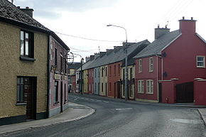
Main street in Clarecastle - geograph.org.uk - 2185454.jpg
Main Street, Clarecastle, part of the R458
Route information
Length49.5 km (30.8 mi)
Major junctions
FromIRL N67.svg N67 Kilcolgan
Major intersectionsR461 Regional Route Shield Ireland.png R461 Gort Tiraloughan
R462 Tiraloughan
Enters County Clare
File:M18 IE.png M18 Motorway Exit 15 Ireland.PNG Junction 15
File:M18 IE.png M18 Motorway Exit 14 Ireland.PNG Junction 14
R871 Regional Route Shield Ireland.png R871 Ennis
R352 Regional Route Shield Ireland.png R352 Ennis
R474 Regional Route Shield Ireland.png R474 Ennis
R475 Regional Route Shield Ireland.png R475 Ennis
R469 Regional Route Shield Ireland.png R469 Ennis
IRL N85.svg N85 Ennis
R473 Regional Route Shield Ireland.png R473 Ennis
Crosses River Fergus and River Rine
File:M18 IE.png M18 Motorway Exit 11 Ireland.PNG Junction 11
R470 Regional Route Shield Ireland.png R470 Newmarket-on-Fergus
R472 Regional Route Shield Ireland.png R472 Boheraroan
IRL N18.svg N18 Shannon
ToR471 Regional Route Shield Ireland.png R471 Clonmoney
Location
CountryRepublic of Ireland
Highway system

The R458 is a long regional road in Ireland, located in County Clare and County Galway.[1][2]

References

  1. ^ "R442 - Roader's Digest: The SABRE Wiki". www.sabre-roads.org.uk.
  2. ^ "S.I. No. 54/2012 - Roads Act 1993 (Classification of Regional Roads) Order 2012". irishstatutebook.ie. Retrieved 22 June 2020.