Puerto Rico Highway 873
Jump to navigation
Jump to search
Highway 873 | ||||
|---|---|---|---|---|
| Ruta 873 (Spanish) | ||||
| Route information | ||||
| Maintained by Puerto Rico DTPW | ||||
| Length | 1.7 km[1] (1.1 mi) | |||
| Major junctions | ||||
| South end | ||||
| North end | ||||
| Location | ||||
| Country | United States | |||
| Territory | Puerto Rico | |||
| Municipalities | San Juan, Guaynabo | |||
| Highway system | ||||
| ||||

Puerto Rico Highway 873 (PR-873) is a north–south road located between the municipalities of San Juan and Guaynabo, Puerto Rico,[2] and it corresponds to an original segment of the historic Carretera Central.[3] The General Norzagaray Bridge is located on this route.[3]
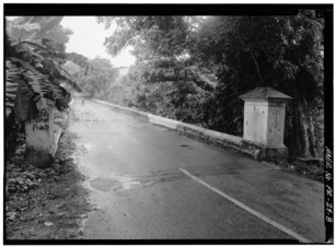
General Norzagaray Bridge looking south
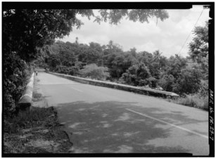
General Norzagaray Bridge looking north
Major intersections
| Municipality | Location | km[1] | mi | Destinations | Notes |
|---|---|---|---|---|---|
| San Juan | Tortugo | 1.7 | 1.1 | PR-1 | Southern terminus of PR-873; the Carretera Central continues toward Guaynabo; access to San Juan and Caguas; unsigned |
| Quebrada Frailes | 0.8– 0.7 | 0.50– 0.43 | Puente General Norzagaray[4] | ||
| Guaynabo | No major intersections | ||||
| San Juan | Caimito | 0.0 | 0.0 | Northern terminus of PR-873; the Carretera Central continues toward San Juan; no access to PR-199 west; PR-1 north access is via PR-199 east; access to San Juan, Caguas and Trujillo Alto | |
| 1.000 mi = 1.609 km; 1.000 km = 0.621 mi | |||||
References
- ^ a b Google (February 29, 2020). "PR-873" (Map). Google Maps. Google. Retrieved February 29, 2020.
- ^ National Geographic Maps (2011). Puerto Rico (Map). 1:125,000. Adventure Map (Book 3107). Evergreen, Colorado: National Geographic Maps. ISBN 978-1566955188. OCLC 756511572.
- ^ a b Pumarada O'Neill, Luis (July 31, 1994). "National Register of Historic Places Registration: General Norzagaray Bridge". National Park Service. Retrieved June 10, 2019. With photos from 1989 & 1993
- ^ Luis F. Pumarada O’Neill (1991). "Los Puentes Históricos de Puerto Rico" (PDF) (in Spanish). pp. 43–44. Retrieved March 10, 2020.
External links
 Media related to Puerto Rico Highway 873 at Wikimedia Commons