Puerto Rico Highway 633
Jump to navigation
Jump to search

Highway 633 | ||||
|---|---|---|---|---|
| Ruta 633 (Spanish) | ||||
| Route information | ||||
| Maintained by Puerto Rico DTPW | ||||
| Length | 4.3 km[1] (2.7 mi) | |||
| Existed | 1953[2]–present | |||
| Major junctions | ||||
| West end | ||||
| East end | ||||
| Location | ||||
| Country | United States | |||
| Territory | Puerto Rico | |||
| Municipalities | Ciales, Morovis | |||
| Highway system | ||||
| ||||
| ||||

Puerto Rico Highway 633 (PR-633) is an east–west rural road located between the municipalities of Ciales and Morovis, Puerto Rico.[3] It begins at its intersection with PR-149[4] in Hato Viejo barrio and ends at its junction with PR-155[5] in Barahona.[6]
Puerto Rico Highway 633 in Barahona, Morovis

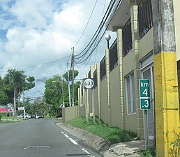
Building on Puerto Rico Highway 633 in Barahona, Morovis


Major intersections
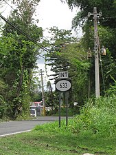
PR-155 near PR-633 intersection in Barahona, Morovis

| Municipality | Location | km[1] | mi | Destinations | Notes |
|---|---|---|---|---|---|
| Ciales | Hato Viejo | 0.0 | 0.0 | Western terminus of PR-633 | |
| Morovis | Barahona | 4.3 | 2.7 | Eastern terminus of PR-633 | |
| 1.000 mi = 1.609 km; 1.000 km = 0.621 mi | |||||
Related route
Highway 6633 | |
|---|---|
| Location | Ciales |
| Length | 0.22 km[7] (0.14 mi; 720 ft) |
Puerto Rico Highway 6633 (PR-6633) is a spur route located in Ciales. It extends from PR-6685 to PR-149, near to PR-633.[8] The entire route is located in Hato Viejo, Ciales.
PR-6633 east in Hato Viejo, Ciales
| km[7] | mi | Destinations | Notes | ||
|---|---|---|---|---|---|
| 0.00 | 0.00 | Western terminus of PR-6633 | |||
| 0.22 | 0.14 | Eastern terminus of PR-6633 | |||
| 1.000 mi = 1.609 km; 1.000 km = 0.621 mi | |||||
See also
References
- ^ a b Google (February 28, 2020). "PR-633" (Map). Google Maps. Google. Retrieved February 28, 2020.
- ^ "Morovis, Memoria Núm. 65" (PDF). Puerto Rico Planning Board (in Spanish). 1955. Retrieved February 22, 2020.
- ^ National Geographic Maps (2011). Puerto Rico (Map). 1:125,000. Adventure Map (Book 3107). Evergreen, Colorado: National Geographic Maps. ISBN 978-1566955188. OCLC 756511572.
- ^ "PR-633, Ciales, Puerto Rico". geoview.info. Retrieved February 22, 2020.
- ^ "PR-633, Morovis, Puerto Rico". geoview.info. Retrieved February 22, 2020.
- ^ "Tránsito Promedio Diario (AADT)". Transit Data (Datos de Transito) (in Spanish). DTOP PR. p. 117. Archived from the original on April 1, 2019.
- ^ a b Google (March 22, 2020). "PR-6633" (Map). Google Maps. Google. Retrieved March 22, 2020.
- ^ "PR-6633, Ciales, Puerto Rico". geoview.info. Retrieved March 22, 2020.