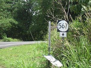
Puerto Rico Highway 567 (PR-567 ) is a north–south rural road located between the municipalities of Orocovis and Morovis, Puerto Rico .[3] PR-157 on the Barros –Damián Arriba line in Orocovis,[4] Vaga , Pasto and San Lorenzo barrios until its end at its intersection with PR-145 and PR-6622 in the Torrecillas –Morovis Norte line in Morovis.[5] [6]
Puerto Rico Highway 567 in Vaga barrio
Major intersections
PR-567 at its junction with PR-5567 in Vaga barrio
PR-6622 west at its junction with PR-145 and PR-567 south between Morovis Norte and Torrecillas barrios
Related route
Highway 5567
Location Morovis Length 2.8 km[7]
Puerto Rico Highway 5567 (PR-5567 ) is a spur route located in Morovis. It extends from PR-567 on the Pasto–Vaga line to Vaga barrio.[8] Morovis .
PR-5567 heading north to Vaga barrio
See also References
^ a b Google (February 29, 2020). "PR-567" (Map). Google Maps . Retrieved February 29, 2020 .^ "Morovis, Memoria Núm. 65" (PDF) . Puerto Rico Planning Board . Retrieved February 22, 2020 .^ National Geographic Maps (2011). Puerto Rico (Map). 1:125,000. Adventure Map (Book 3107). Evergreen, Colorado: National Geographic Maps. ISBN 978-1566955188 OCLC 756511572 . ^ "PR-567, Orocovis, Puerto Rico" . geoview.info . Retrieved February 22, 2020 .^ "Tránsito Promedio Diario (AADT)" . Transit Data (Datos de Transito) (in Spanish). DTOP PR. p. 116. Archived from the original on April 1, 2019.^ "PR-567, Morovis, Puerto Rico" . geoview.info . Retrieved February 22, 2020 .^ a b Google (March 22, 2020). "PR-5567" (Map). Google Maps . Retrieved March 22, 2020 .^ "PR-5567, Morovis, Puerto Rico" . geoview.info . Retrieved March 22, 2020 .
External links


