Puerto Rico Highway 171
Jump to navigation
Jump to search
Highway 171 | ||||
|---|---|---|---|---|
| Ruta 171 (Spanish) | ||||
| Route information | ||||
| Maintained by Puerto Rico DTPW | ||||
| Length | 8.3 km[1] (5.2 mi) | |||
| Existed | 1953[2]–present | |||
| Major junctions | ||||
| South end | ||||
| North end | ||||
| Location | ||||
| Country | United States | |||
| Territory | Puerto Rico | |||
| Municipalities | Cayey, Cidra | |||
| Highway system | ||||
| ||||

Puerto Rico Highway 171 (PR-171) is a road that travels from Cidra, Puerto Rico to Cayey.[3] It begins at its intersection with PR-172 in downtown Cidra and ends at its junction with PR-14 near downtown Cayey.[4]
Major intersections

PR-7733 west at PR-171 junction in Sud, Cidra
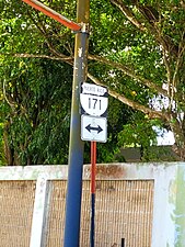
Sign for PR-171 at PR-7733 junction in Sud, Cidra
.jpg)
.jpg)
| Municipality | Location | km[1] | mi | Destinations | Notes |
|---|---|---|---|---|---|
| Cayey | Cayey barrio-pueblo | 8.3 | 5.2 | Southern terminus of PR-171 | |
| Rincón | 6.1 | 3.8 | |||
| Cidra | Rincón | 5.4 | 3.4 | ||
| 4.6 | 2.9 | ||||
| 4.2– 4.1 | 2.6– 2.5 | ||||
| Sud | 0.6 | 0.37 | |||
| Cidra barrio-pueblo | 0.0 | 0.0 | Northern terminus of PR-171 | ||
| 1.000 mi = 1.609 km; 1.000 km = 0.621 mi | |||||
See also
References
- ^ a b Google (March 2, 2020). "PR-171" (Map). Google Maps. Google. Retrieved March 2, 2020.
- ^ "Cayey, Memoria Núm. 42" (PDF). Puerto Rico Planning Board (in Spanish). 1955. Retrieved August 4, 2020.
- ^ National Geographic Maps (2011). Puerto Rico (Map). 1:125,000. Adventure Map (Book 3107). Evergreen, Colorado: National Geographic Maps. ISBN 978-1566955188. OCLC 756511572.
- ^ "Tránsito Promedio Diario (AADT)". Transit Data (Datos de Transito) (in Spanish). DTOP PR. p. 90. Archived from the original on April 1, 2019.
External links
 Media related to Puerto Rico Highway 171 at Wikimedia Commons