Puerto Rico Highway 139
Highway 139 | |||||||||
|---|---|---|---|---|---|---|---|---|---|
| Ruta 139 (Spanish) | |||||||||
.svg) | |||||||||
| Route information | |||||||||
| Maintained by Puerto Rico DTPW | |||||||||
| Length | 25.2 km[1] (15.7 mi) | ||||||||
| Major junctions | |||||||||
| South end | |||||||||
| North end | |||||||||
| Location | |||||||||
| Country | United States | ||||||||
| Territory | Puerto Rico | ||||||||
| Municipalities | Ponce | ||||||||
| Highway system | |||||||||
| |||||||||
| |||||||||


Puerto Rico Highway 139 (PR-139) is a two-way secondary[2] highway in the municipality of Ponce, Puerto Rico.
Route description
The road runs north to south, and mostly alongside Río Cerrillos in barrio Maragüez, borders the edge of Lake Cerrillos, and then runs through barrio Cerrillos and from there into the city of Ponce.[3]
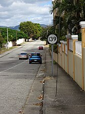
Sign on PR-139, a few yards from the start of the route in Ponce, Puerto Rico, looking northeast

Puerto Rico Highway 139 (PR-139) in Barrio Maraguez, Ponce, heading south, with the City of Ponce and the Río Portugués channel in the background and the Caribbean Sea in the far background
.jpg)
.jpg)
Communities served
As the road is traveled in a northbound fashion, it serves barrios Machuelo Arriba, Maragüez, and Anón.
Major intersections
| Municipality | Location | km[1] | mi | Destinations | Notes |
|---|---|---|---|---|---|
| Ponce | Machuelo Arriba | 0.0 | 0.0 | Southern terminus of PR-139; diamond interchange | |
| 0.3– 0.4 | 0.19– 0.25 | ||||
| 3.2 | 2.0 | ||||
| Ponce–Jayuya municipal line | Anón–Jauca line | 25.2 | 15.7 | Northern terminus of PR-139 | |
| 1.000 mi = 1.609 km; 1.000 km = 0.621 mi | |||||
Related routes
Currently, Puerto Rico Highway 139 has two branches along its route in Ponce.
Puerto Rico Highway 139R
Highway 139R | |
|---|---|
| Location | Ponce |
| Length | 2.9 km[4] (1.8 mi) |
Puerto Rico Highway 139R (Spanish: Carretera Ramal 139, abbreviated Ramal PR-139 or PR-139R) is a spur route or ramal from its parent route PR-139, and the main (and only) access to Cerrillos Dam and Luis A. "Wito" Morales Park.[5] The entire route is located in Ponce.
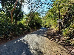
PR-139R in Machuelo Arriba

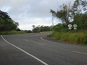
PR-139 at its junction with PR-139R and PR-5139
.jpg)
,_Bo._Machuelo_Arriba,_Ponce,_PR_(DSC04242).jpg)
| Location | km[4] | mi | Destinations | Notes | |
|---|---|---|---|---|---|
| Machuelo Arriba | 0.0 | 0.0 | Southern terminus of PR-139R | ||
| Maragüez | 2.9 | 1.8 | Luis A. "Wito" Morales Park – Cerrillos Dam | Northern terminus of PR-139R; dead end road | |
| 1.000 mi = 1.609 km; 1.000 km = 0.621 mi | |||||
Puerto Rico Highway 5139
Highway 5139 | |
|---|---|
| Location | Ponce |
| Length | 2.8 km[6] (1.7 mi) |
Puerto Rico Highway 5139 (PR-5139) is a north–south connector located between PR-14 and PR-139. This road runs through Cerrillos and Machuelo Arriba barrios, crossing Cerrillos River near Cerrillos Dam.[7] The entire route is located in Ponce.

PR-5139 in Machuelo Arriba
PR-5139 at its junction with PR-139 and PR-139R
.jpg)
.jpg)
| Location | km[6] | mi | Destinations | Notes | |
|---|---|---|---|---|---|
| Cerrillos | 0.0 | 0.0 | Southern terminus of PR-5139 | ||
| Machuelo Arriba | 2.8 | 1.7 | Northern terminus of PR-5139 | ||
| 1.000 mi = 1.609 km; 1.000 km = 0.621 mi | |||||
See also
References
- ^ a b Google (March 2, 2020). "PR-139" (Map). Google Maps. Google. Retrieved March 2, 2020.
- ^ PRHTA Design Manual. Manual de Especificaciones y Diseño; General Design Criteria. San Juan, Puerto Rico: Puerto Rico DTOP. Pages 1-2 and 1-3. Accessed 30 April 2019.
- ^ "Tránsito Promedio Diario (AADT)". Transit Data (Datos de Transito) (in Spanish). DTOP PR. p. 77. Archived from the original on April 1, 2019.
- ^ a b Google (March 2, 2020). "PR-139R" (Map). Google Maps. Google. Retrieved March 2, 2020.
- ^ National Geographic Maps (2011). Puerto Rico (Map). 1:125,000. Adventure Map (Book 3107). Evergreen, Colorado: National Geographic Maps. ISBN 978-1566955188. OCLC 756511572.
- ^ a b Google (August 16, 2020). "PR-5139" (Map). Google Maps. Google. Retrieved August 16, 2020.
- ^ "PR 5139 over CERILLO RIVER, Ponce, Puerto Rico". bridgereports.com. Retrieved 7 January 2022.