Puerto Rico Highway 121
Jump to navigation
Jump to search
Highway 121 | ||||
|---|---|---|---|---|
| Ruta 121 (Spanish) | ||||
| Route information | ||||
| Maintained by Puerto Rico DTPW | ||||
| Length | 15.4 km[1] (9.6 mi) | |||
| Major junctions | ||||
| West end | ||||
| East end | ||||
| Location | ||||
| Country | United States | |||
| Territory | Puerto Rico | |||
| Municipalities | Sabana Grande, Yauco | |||
| Highway system | ||||
| ||||


Puerto Rico Highway 121 (PR-121) is a road that travels from Sabana Grande, Puerto Rico to Yauco.[2] This highway begins at its intersection with PR-102 and PR-368 in downtown Sabana Grande and ends at its junction with PR-127 and PR-128 in Susúa Baja.[3]
Major intersections

PR-2 west approaching exit 183 to PR-121 in Rayo, Sabana Grande
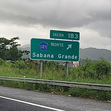
PR-2 west at exit 183 to PR-121 near Sabana Grande barrio-pueblo
.jpg)
.jpg)
| Municipality | Location | km[1] | mi | Destinations | Notes |
|---|---|---|---|---|---|
| Sabana Grande | Sabana Grande barrio-pueblo | 0.0 | 0.0 | Western terminus of PR-121 | |
| Machuchal–Rayo line | 0.6– 0.7 | 0.37– 0.43 | PR-2 exit 183 | ||
| 1.3 | 0.81 | ||||
| 2.4 | 1.5 | ||||
| 4.2 | 2.6 | PR-2 exit 187 | |||
| 5.2 | 3.2 | ||||
| Susúa | 8.6– 8.7 | 5.3– 5.4 | |||
| Yauco | Susúa Baja | 13.6 | 8.5 | Former PR-116R | |
| 14.2 | 8.8 | Avenida Luis Muñoz Marín – Yauco | |||
| 15.4 | 9.6 | Eastern terminus of PR-121 | |||
| 1.000 mi = 1.609 km; 1.000 km = 0.621 mi | |||||
References
- ^ a b Google (March 3, 2020). "PR-121" (Map). Google Maps. Google. Retrieved March 3, 2020.
- ^ National Geographic Maps (2011). Puerto Rico (Map). 1:125,000. Adventure Map (Book 3107). Evergreen, Colorado: National Geographic Maps. ISBN 978-1566955188. OCLC 756511572.
- ^ "Tránsito Promedio Diario (AADT)". Puerto Rico Department of Transportation and Public Works (in Spanish). pp. 68–69. Archived from the original on April 1, 2019. Retrieved June 5, 2019.
External links
 Media related to Puerto Rico Highway 121 at Wikimedia Commons