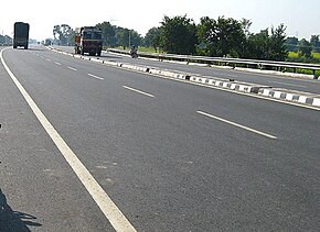
National Highway 57 (India, old numbering)
Jump to navigation
Jump to search
 | ||||
 Old NH 57 in Bihar | ||||
| Route information | ||||
| Length | 310 km (190 mi) | |||
| Major junctions | ||||
| From | Muzaffarpur | |||
| NH 77, NH 106 | ||||
| To | Purnea | |||
| Location | ||||
| Country | India | |||
| States | Bihar | |||
| Primary destinations | Darbhanga - Muria - Sakri - Jhanjharpur - Bhaptiyahi - Simrahi - Narahia - Narpatganj - Forbesganj - Araria | |||
| Highway system | ||||
| ||||
Former National Highway 57 linked Muzaffarpur to Purnea in the Indian state of Bihar. It was 310 km (190 mi) long.[1] In 2010 the national highway numbering system was rationalized and renumbered.[2] The entire stretch of the old national highway 57 is now part of new National Highway 27.[3]
Route
This former national highway passed through Muzaffarpur, Darbhanga, Muria, Supaul, Narahia, Narpatganj, Forbesganj, Araria, Jhanjharpur and Purnia.
See also
- List of National Highways in India by old highway number
- List of National Highways by new numbering
- National Highways Development Project
- Transport in Bihar
- List of National Highways in Bihar
References
- ^ [1] Archived 10 February 2010 at the Wayback Machine Length of National Highways-Source-Government of India
- ^ "Rationalisation of Numbering Systems of National Highways" (PDF). New Delhi: Department of Road Transport and Highways. Archived from the original (PDF) on 4 December 2018. Retrieved 14 February 2020.
- ^ "The List of National Highways in India" (PDF). Ministry of Road Transport and Highways. Retrieved 14 February 2020.