Mayapa–Canlubang Cadre Road
Mayapa–Canlubang Cadre Road | |
|---|---|
| Mayapa Road | |
 Mayapa–Canlubang Cadre Road in Canlubang | |
| Route information | |
| Length | 2.768 km[1] (1.720 mi) |
| Major junctions | |
| West end | Jose Yulo, Sr. Avenue and Silangan Industrial Park Road in Canlubang |
| East end | |
| Location | |
| Major cities | Calamba, Laguna |
Mayapa–Canlubang Cadre Road, also known as Mayapa Road, is a two- to four-lane, tertiary national road, located in Calamba, Laguna in the Philippines. It spans 2.768 kilometers (1.720 mi)* stretching from the "Checkpoint" area at the intersection with Manila South Road in barangay Paciano Rizal to Jose Yulo Sr. Avenue and Silangan Industrial Park Road (Doña Cecila Yulo Avenue) in barangay Canlubang. This road adjoins the Canlubang Exit of South Luzon Expressway.[2]
In 2015, the road was reclassified from barangay road to tertiary national road.[1][3]
Landmarks

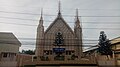
Mary Help of Christians Parish in Mayapa
Iglesia ni Cristo–Mayapa Church

Camp Gen. Vicente P. Lim Gate 1
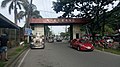
Barangay Canlubang welcome arch denotes the west end of Mayapa–Canlubang Cadre Road


References
- ^ Jump up to: a b "Newly Reclassified Local Roads into National Roads in 2015". Department of Public Works and Highways. Retrieved September 4, 2018.
- ^ "DPWH Road Data | Laguna 2nd". Department of Public Works and Highways Website. DPWH. Archived from the original on January 10, 2014. Retrieved September 4, 2018.
- ^ "Declaring the Whole Stretch of Mayapa–Canlubang Cadre Road as a National Road Under the Jurisdiction of Laguna 2nd District Engineering Office, Region IV-A" (PDF). Department of Public Works and Highways. Retrieved September 4, 2018.