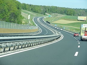
A5 (Slovenia)
Jump to navigation
Jump to search
| Avtocesta A5 (Slovene) | |
 | |
| Route information | |
| Length | 79.6 km (49.5 mi) |
| Major junctions | |
| From | |
| To | Pince |
| Location | |
| Country | Slovenia |
| Regions | Lower Styria, Prekmurje |
| Major cities | Maribor, Murska Sobota, Lendava |
| Highway system | |
The A5 motorway (Slovene: avtocesta A5, Pomurski krak) of Slovenia is 79.6 km long. It begins at the Dragučova interchange on the A1 motorway north of Maribor and ends at the Hungarian border at Pince, continuing on in Hungary as the M70 motorway. It connects Maribor with Budapest.
The first section was completed in 2003, whilst the last section was opened for traffic in October 2008.
Junctions, exits and rest area
This article contains a bulleted list or table of intersections which should be presented in a properly formatted junction table. |
| A1 (Dragučova) – Pince (79,56 km) | ||||
| x km | Dragučova interchange | A1 | ||
| x km | Pernica | |||
| Močna Viaduct | Bridge - 166 / 167 m | |||
| Močna covered cut | Tunnel - 360 m | |||
| x km | Lenart | |||
| x km | Počivališče Lormanje |
Petrol / MOL | ||
| x km | Sveta Trojica | |||
| x km | Cerkvenjak | |||
| Cenkova covered cut | Tunnel - 258 / 241 m | |||
| Cenkova Tunnel | Tunnel - 357 / 361 m | |||
| x km | Počivališče Sv. Jurij |
714 | OMV / Petrol | |
| Sveti Jurij ob Ščavnici | ||||
| x km | Vučja Vas | |||
| Mur River | Bridge - 833 / 877 m | |||
| x km | Murska Sobota | |||
| x km | Počivališče Murska Sobota |
Petrol / Petrol | ||
| x km | Lipovci | 232 | ||
| x km | Gančani | |||
| x km | Počivališče Dolisko |
|||
| x km | Turnišče | |||
| x km | Dolga Vas interchange | H7 turns toward -> | ||
| x km | Lendava | 443 |
||
| x km | Počivališče Pince |
Petrol / MOL | ||
| Pince | ||||
| x km | Pince (SLO) – Tornyiszentmiklós (H) border crossing | |||
European Route(s)
| Name | Route | |
| 79,6 km | ||
External links
- DARS, the national motorway operator of Slovenia.
- Exit list of A5
Media related to A5 (Slovenia) at Wikimedia Commons