M49 (Hungary)
(Redirected from M49 expressway (Hungary))
Jump to navigation
Jump to search
You can help expand this article with text translated from the corresponding article in Hungarian. Click [show] for important translation instructions.
|
 | |
| Route information | |
| Length | 45 km (28 mi) (planned length) |
| Major junctions | |
| From | |
| |
| To | |
| Location | |
| Country | Hungary |
| Counties | Szabolcs-Szatmár-Bereg |
| Highway system | |
| |
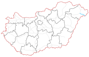
The M49 expressway (Hungarian: M49-es autóút) is a planned 45 km (28 mi) long expressway in Hungary that will link the M3 motorway to the border with Romania near Csenger, connecting with Romania's A14 motorway towards Satu Mare. Upon completion, it will serve as a continuation of the Romanian high-speed road to Budapest, the capital of Hungary.[1][2]
Timeline
| Section | Length | Opened | Notes |
|---|---|---|---|
| Vaja (M3) – Ököritófülpös | 28.2 km (17.52 mi) | Planned in 2026 | Under construction |
| Ököritófülpös – Csenger (border) | 17.5 km (10.87 mi) | Planned |
Route description
- The route will be full length expressway. The maximum speed limit is 110 km/h, with
(2x2 lane road).
This article contains a bulleted list or table of intersections which should be presented in a properly formatted junction table. |
| County | km | Type | Destination | Notes | |
|---|---|---|---|---|---|
Szabolcs-Szatmár-Bereg |
0 | The western terminus of the Kilometrage starting point Western under construction section | |||
| 1 | |||||
| 7 | |||||
| 14 | Mátészalkai pihenőhely | pihenőhely means Rest area | |||
| 13 | Kraszna híd | híd means Bridge | |||
| 14 | |||||
| 28 | Eastern under construction section | ||||
| 31 | Porcsalma, Tyukod | Planned | |||
| 41 | Csenger / Csengerújfalu | ||||
| 45 | Csenger (H) – Vetiș-Oar II. (RO) border crossing |
Planned | |||
1.000 mi = 1.609 km; 1.000 km = 0.621 mi
| |||||
See also
References
- ^ "M49 – Gyorsforgalmi út épül Mátészalkától a román határig". azuzlet.hu (in Hungarian).
- ^ "Indul a Mátészalkától az erdélyi határig futó M49-es tervezése". magyarepitok.hu (in Hungarian).
External links
- National Toll Payment Services Plc. (in Hungarian, some information also in English)
- National Infrastructure Developer Ltd.