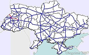
Highway M09 is a Ukrainian international highway (M-highway) which is part of the Warsaw - Lviv route. It starts as a split-off from the M12 near Ternopil, runs through Lviv, then turns north and heads towards the border with Poland. The highway terminates at the border checkpoint Rava-Ruska. Across the Polish border it continues as National Road 17 (DK17).[1][2] The section between Rava-Ruska and Lviv is part of European route E372.

Road sign on the M09 near Rava-Rus'ka
History
This route belonged until 1918 to the Austrian crown land of Galicia and its section between Lviv and Rava was called the Żółkiewer Reichsstraße.[3]
Route
| Marker |
Main settlements |
Notes |
Highway Interchanges
|
| Ternopil Oblast
|
| 0 km
|
Arboretum "Karpaty"
|
starts at "Berezhanska konyushyna"
|
 M 12 M 12
|
|
|
Chahari Kutkivetski Botanic Reserve
|
|
P 41
|
|
|
Zboriv
|
|
T2014 • T2013
|
| Lviv Oblast
|
|
|
Zolochiv • Yasenivtsi
|
|
T1413
|
|
|
Yaktoriv
|
|
T1806
|
|
|
Pidhaichyky • Kurovychi
|
|
T1417
|
|
|
Kurovychi
|
|
T1425
|
| 111.9 km
|
Vynnyky
|
|
 M 06 M 06
|
See also
References
External links

