Greenhill Road
This article needs additional citations for verification. |
Greenhill Road | |
|---|---|
| Route information | |
| Length | 27.7 km[1] (17.2 mi) |
| Allocation |
|
| Major junctions | |
| West end | Keswick, Adelaide |
| |
| East end | Balhannah, South Australia |
| Location | |
| Country | Australia |
| State | South Australia |
| Primary destinations | Parkside, Glenside, Burnside, Greenhill, Uraidla, Carey Gully |
| Major cities | Adelaide |
| Highway system | |
| Highways in South Australia | |
Greenhill Road is a major road in Adelaide, South Australia,[2] that provides a connection to the eastern and hills suburbs. Its western section, running along the south side of Adelaide Parklands, forms part of Adelaide's City Ring Route.
Route
The eastern end of Greenhill Road is in Balhannah in the Adelaide Hills. It winds through Carey Gully, Uraidla, Summertown and Greenhill as a two-lane road.
In the metropolitan area, it is four lanes and passes by the City of Burnside suburbs of Burnside, Hazelwood Park, Linden Park, Tusmore, Toorak Gardens, Dulwich and Glenside until it reaches the edge of the Adelaide Parklands. The road then expands to six lanes and heads past Eastwood and the City of Unley suburbs of Parkside, Unley and Wayville as part of the City Ring Route. This section was originally designated "Park Terrace".[3]
Greenhill Road continues west as Richmond Road from the intersection of Anzac Highway.
Major intersections
| LGA[4] | Location[1][5] | km[1] | mi | Destinations | Notes |
|---|---|---|---|---|---|
| Adelaide–Unley boundary | Adelaide–Wayville boundary | 0.0 | 0.0 | Route R1 continues west as Richmond Road | |
| 0.5 | 0.31 | Goodwood Road – Adelaide CBD, Hindmarsh | |||
| 1.0 | 0.62 | Sir Lewis Cohen Avenue – Adelaide CBD | |||
| Adelaide–Wayville–Unley tripoint | 1.5 | 0.93 | Glenelg tram line | ||
| Adelaide–Unley boundary | 1.6 | 0.99 | Peacock Road (north) – Adelaide CBD King William Road (south) – Unley Park | ||
| Adelaide–Unley–Parkside tripoint | 2.1 | 1.3 | |||
| Adelaide–Parkside boundary | 2.7 | 1.7 | Hutt Road (north) – Adelaide CBD George Street (south) – Parkside | ||
| Adelaide–Unley–Burnside tripoint | Adelaide–Parkside–Eastwood tripoint | 2.9 | 1.8 | Glen Osmond Road – Adelaide CBD, Glen Osmond | |
| Adelaide–Burnside boundary | Eastwood–Glenside–Dulwich | 3.7 | 2.3 | Route R1 continues north along Fullarton Road Western terminus of route B26 | |
| Burnside | Toorak Gardens–Tusmore–Linden Park–Glenside quadripoint | 5.4 | 3.4 | ||
| Hazelwood Park–Burnside boundary | 7.0 | 4.3 | Glynburn Road – Hectorville, Beaumont | ||
| Adelaide Hills | Greenhill–Summertown boundary | 14.4 | 8.9 | ||
| Summertown | 16.3 | 10.1 | Piccadilly Road – Crafers | ||
| Uraidla | 17.7 | 11.0 | Basket Range Road – Basket Range | ||
| Balhannah | 27.7 | 17.2 | Eastern terminus of route B26 | ||
1.000 mi = 1.609 km; 1.000 km = 0.621 mi
| |||||
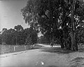
Horse and cart using Greenhill Road, 1915

Greenhill Road near Linden Park, facing east towards the Adelaide Hills
Greenhill Rd in Hazelwood Park looking toward Glynburn Road roundabout and the hills
.jpg)


Tram stop
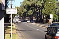
Greenhill Road is also the location of a stop on the Glenelg tram line.[6]
References
- ^ Jump up to: a b c Google (16 June 2022). "Greenhill Road" (Map). Google Maps. Google. Retrieved 16 June 2022.
- ^ 2003 Adelaide Street Directory, 41st Edition. UBD (A Division of Universal Press Pty Ltd). 2003. ISBN 0-7319-1441-4.
- ^ "Motoring News". The News. Adelaide: National Library of Australia. 23 November 1953. p. 20. Retrieved 28 July 2014.
- ^ "Location SA Map viewer with LGA layers". Government of South Australia. Retrieved 16 June 2022.
- ^ "Location SA Map viewer with suburb layers". Government of South Australia. Retrieved 16 June 2022.
- ^ Glenelg Tram Timetable (2018) Archived 2 April 2019 at the Wayback Machine, Adelaide Metro